Power Line Maintenance Inspection
Track Clearance or Right of Way inspection
The Track Clearance is a component of the Power Line Maintenance Inspection System based on the Airborne LiDAR [ASLMS]. It is used for track clearance inspection, also known as right-of-way (ROW).
Fitting the ASLMS with software dedicated to over-head line geometric modelling, produces a quantitative track clearance or right-of-way report while the inspectors on the aircraft perform other duties, such as visual inspection or thermography inspection.
It is an automatic, real-time solution for track clearance (right-of-way), featuring obstacle detection and classification and report generation.
Other features can be added in post processing, such as sag computation, line profiling, vegetation management algorithms and three dimension (3D) modelling of the environment around the over-head line.
The Track Clearance performs the right-of-way inspection automatically and in real time while the inspectors focus on other types of inspections, such as thermography or visual detection of mechanical issues.
- The LiDAR sweeps the scenario detecting objects
- The real-time algorithms classify the points
- The real-time clearance algorithms measure distances between conductors and other objects. If the clearance (right-of-way) is infringed (3.95m) a point of interest is generated.
- The GPS reading localises the point of interest.
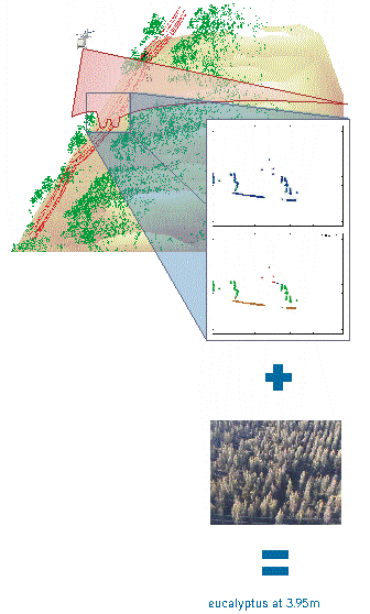
- Combined with the visual analysis, the clearance issue is associated to an eucalyptus.
Introduction to Track Clearance
When operating in real-time over a power-line (follow the illustration), the ASLMS sweeps the line track to deliver sequences of two dimension (2D) angular scans with range data measured from the aircraft (top insert, samples in blue).
The Track Clearance software identifies the elements in the scan (middle insert, samples in red, brown and green):
- ground (brown),
- conductors (red),
- towers (black, not shown),
- constructions (dark blue, not shwon) and
- other objects, most often vegetation (green).
If the free envelope around the power line conductors required by regulations or safety practices is breached, an anomaly is identified and communicated to the operator. In the example, a distance of 3.95m was found while the requirements set the safety limit at 4m for this particular line.
A video snapshot (lower image) is associated to each laser profile to support fault classification. In the example, the inspector readily identifies the anomaly as an eucalyptus at 3.95m from the line.
The associated GPS localises the event in absolute coordinates to assist ground teams to incorporate the anomaly into the preventive maintenance assignments.
Vegetation Management
In addition to the detection of clearance infractions, the vegetation data is used to compute different relevant variables
The Track Clearance introduces innovative features:
- the track clearance inspection is automatic and does not require any attention from the human operators during flight,
- the track clearance inspection is performed in real time, allowing immediate in-flight validation if the operator so requires
- it combines laser, video and GPS to create a thorough geo-referenced model of the power line,
- the anomaly report may be generated immediately following the mission and critical issues are reported at once,
- Allows operator to make informed decisions on whether to investigate encountered anomalies
- the inspection data can be reprocessed at a later date to detect critical spans, determine catenaries profiles and estimate ground clearance under different current capacity,
- the data can be uploaded to asset management databases supporting preventive maintenance schedules, power capacity optimization tools and contingency operation plans.
The Track Clearance offers the following benefits:
- Enhances continuity of power supply by reducing the number of outages,
- Improves power quality by reducing the number and severity of voltage sags and disturbances dur to forest fires.
- Prevents environmental hazards by reducing the likelihodd of forest fires related to over-head power lines
- Contributes to asset management databases by supplying quantitative approaches to track clearance procedures
If airborne missions are already a part of the maintenance program the Track Clearance can be easily integrated with other sensors to provide a more complete inspection in a single pass eliminating the need for dedicated ground or airborne vegetation management inspections.
For integration with other sensors please see the PLMI solution.
To understand the Albatroz clearance report, please read its detailed explanation.
The next movie (90s, 7.5Mb, AVI format) presents the classified data as they are observed inside the helicopter. The image on the right shows the 3D model of the same data.
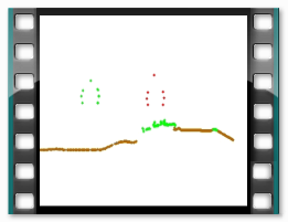
Flight i nterface snapshot with LiDAR data classified and right-of-way measurement in real time

Example of 3D model created by the track clearance software
| ©2013 Albatroz Engineering Inc. All rights reserved. | site map | webmaster |